Metar-Taf - Visual decoder

Metar-Taf - Visual decoder
Visual aviation weather decoder for pilots and enthusiasts
Screenshots
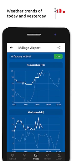
Metar-Taf - Visual decoder: Aviation Weather Simplified
Metar-Taf - Visual decoder is a specialized mobile application designed to decode and visualize aviation weather reports, specifically METAR (Meteorological Aerodrome Report) and TAF (Terminal Aerodrome Forecast) data. The app transforms complex alphanumeric weather codes used by pilots and meteorologists into intuitive, color-coded visual charts and graphs. It provides real-time access to global airport weather conditions, including wind speed and direction, visibility, cloud cover, temperature, pressure, and significant weather phenomena. The application serves as a bridge between raw technical data and actionable insights, making it accessible for both aviation professionals and enthusiasts.
Chapter 1: Function
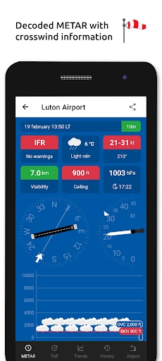
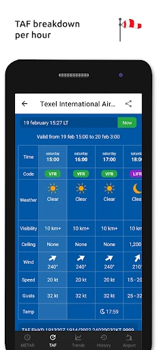
The core function of Metar-Taf - Visual decoder is to parse and visually represent raw METAR and TAF codes. Users input or search for an airport by ICAO code, and the app instantly decodes the string into a readable format. It breaks down each component—such as wind, visibility, weather conditions, sky condition, temperature, and altimeter setting—using color-coded indicators and simple icons. For example, wind direction and speed are shown as an arrow on a compass rose, while cloud layers are displayed as stacked bars. The app also highlights critical changes, like sudden visibility drops or wind shear warnings, with visual alerts. It supports both current conditions (METAR) and 24-30 hour forecasts (TAF), allowing users to swipe between reports. Additionally, it offers a history view to track weather trends at a specific airport over the past few hours.
Chapter 2: Value
The primary value of Metar-Taf - Visual decoder lies in its ability to eliminate interpretation errors and save time. For pilots, flight planners, and dispatchers, misreading a single code element—such as confusing gust wind notation with variable wind—can lead to unsafe decisions. The app reduces cognitive load by presenting data in a graphical format that aligns with human spatial reasoning. Its key advantage is speed: a typical METAR string contains 50-80 characters; the app decodes it in less than a second and displays it as an instantly comprehensible panel. Another advantage is its global coverage—it pulls from official meteorological sources for over 10,000 airports worldwide. The app also works offline by caching recent reports, which is crucial for pilots flying in remote areas without cellular service. For aviation students and hobbyists, it serves as a learning tool, as users can tap any decoded element to see its raw code equivalent, reinforcing the relationship between notation and weather condition. Compared to generic weather apps, Metar-Taf - Visual decoder focuses exclusively on aviation-grade precision, using ICAO standards and providing unit toggle between metric and imperial. The visual approach also minimizes language barriers, as the graphics are universally understood across international aviation communities.
Chapter 3: Scenarios
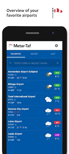
Primary target user groups include private pilots, commercial airline crew, flight dispatchers, air traffic controllers, and aviation meteorology students. Everyday use cases cover pre-flight briefing, in-flight weather monitoring, and training. For example, a private pilot before a cross-country flight uses the app to check METAR and TAF for departure, destination, and alternate airports. The visual wind arrow helps them decide which runway to expect, while cloud layer bars inform visibility during approach. A flight dispatcher monitors multiple airports by bookmarking frequent routes; the app alerts them if a TAF shows deteriorating conditions at an arrival airport. For an aviation student practicing for an instrument rating, the app provides side-by-side comparison of raw codes and their decoded visuals, helping them memorize code patterns. In flight training schools, instructors use the app to quickly demonstrate how a METAR changes throughout a lesson without manually decoding strings on a whiteboard. The app is also used by drone pilots who need METAR data under FAA Part 107 regulations to assess low-altitude wind and visibility. In emergency scenarios, such as a sudden thunderstorm near an airport, the app highlights red flags like heavy rain or microburst symbols, enabling rapid go-around decisions.
Advantages
- decodes raw METAR/TAF into visual weather symbols instantly
- works offline after downloading airport data cache
- color-coded wind barbs show direction and speed at a glance
- parses over 90 aviation weather codes without internet
- tap any symbol to see plain-English explanation of the code
Disadvantages
- no flight planning or route weather integration
- limited to standard aviation stations only
- manual data updates required; no auto-refresh
- lack of METAR/TAF comparison for alternate airports
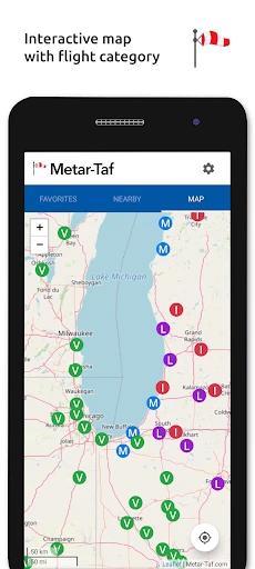
- map view too zoomed-out for precise local conditions
Frequently Asked Questions
Q: What does Metar-Taf Visual decoder do?
A: Metar-Taf Visual decoder translates aviation weather reports (METAR) and forecasts (TAF) into visual, easy-to-read graphics. It decodes raw text data into icons, color-coded conditions, and trend displays for pilots and aviation enthusiasts. No subscription is required for basic decoding, but premium features may include extended forecasts or historical data. The app focuses on clarity and speed, removing the need to manually interpret coded weather strings.
Q: Is the app free or does it require in-app purchases?
A: The app is free to download with core decoding functionality included. Some advanced features, such as custom alert thresholds or detailed trend analysis, may require one-time in-app purchases. There are no recurring subscriptions. No additional equipment is needed beyond a smartphone or tablet. Permissions for location access are optional but enhance local weather retrieval.
Q: Which devices and systems support Metar-Taf Visual decoder?
A: The app is compatible with iOS 14.0+ and Android 8.0+ devices, including iPhones, iPads, and most Android smartphones. It is optimized for both phone and tablet screens. No external sensors or hardware are required. It supports multiple languages and time zone adjustments. Users should ensure a stable internet connection for real-time data updates.
Q: null
A: The visualizations are directly based on official METAR and TAF data from global aviation authorities like NOAA and ICAO. The app does not alter or predict weather; it simply decodes and displays the raw data visually. Updates occur as often as the source reports (typically every 30-60 minutes). Accuracy depends on the original data, not the app’s translation.
Q: null
A: Yes, the app is designed to make weather reports accessible to non-pilots by converting coded text into icons, wind arrows, and color scales. No prior decoding skill is needed. However, understanding basic weather terms like visibility or ceiling height helps interpret the graphics. The app includes a brief legend for common symbols. It is also useful for flight simmers and weather hobbyists.
Technical Information
Recommended for You

Ecosia - Safe Internet Browser

YouVersion Bible App + Audio

Udemy - Online Courses

Solocator - GPS Field Camera

Hardee’s®

New York Post for Phone

OBD Scanner ELM327: GaragePro

Cox Panoramic Wifi

The Dyrt: RV & Free Camping

Pink Cute Hippo Theme

Aadhan: Breaking & Short News

BuzzKill Notification Manager

Weather

BOSS Money Transfer. Send Cash

Blood Pressure Log - MyDiary

Screen Recorder - AZ Recorder

Paramount+

Filter for Selfie

ConnectNetwork by GTL

Victoria's Secret—Bras & More

Telehealth by SimplePractice

VicoHome: Smart Home Camera

Paylocity
