Weather Forecast (Radar Map)
Weather Forecast (Radar Map)
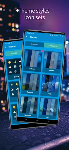
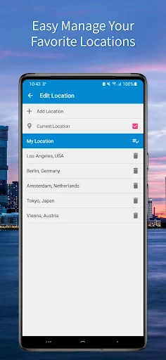
Weather radar alerts for accurate daily planning
Screenshots
Weather Forecast (Radar Map) Comprehensive Feature Analysis
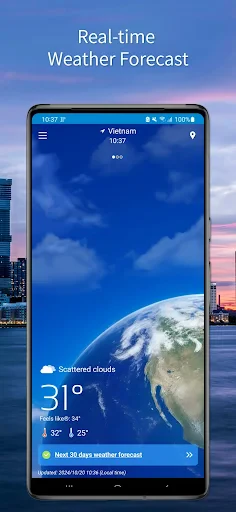
Weather Forecast (Radar Map) is a mobile application designed to provide real-time meteorological data with a focus on high-resolution radar imagery. It enables users to track precipitation, storms, and atmospheric changes through interactive maps. The app integrates data from multiple weather stations to offer accurate current conditions, hourly, and 7-day forecasts. Its core functionality revolves around dynamic radar overlays that display rain, snow, and wind patterns, allowing users to visualize weather movements in their area. The interface prioritizes clarity and speed, ensuring users can access critical information during severe weather events. With customizable alerts and location-based updates, the app serves as a reliable tool for planning daily activities and emergency preparedness. It supports global regions but emphasizes severe weather-prone areas, making it a utility for both casual users and professionals who require precise meteorological data.
Chapter 1: Function
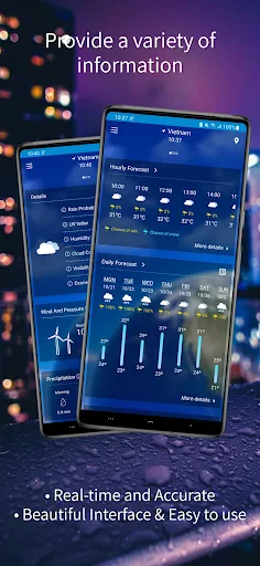
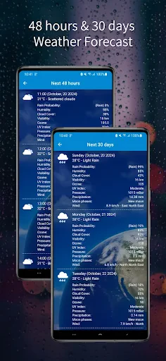
The app’s primary function is to deliver interactive radar maps that update in real time, showing precipitation intensity, storm tracks, and cloud cover. Users can pinch-to-zoom and swipe across the map to view weather patterns at different times, with a timeline slider to forecast movement hours ahead. It includes a layers feature that toggles between radar, satellite, temperature, and wind speed views. The app also sends push notifications for severe weather alerts like tornadoes, floods, or lightning strikes, based on the user’s saved locations. A smart widget displays the current temperature and radar summary on the home screen without opening the app. Additionally, it offers a daily breakdown with UV index, humidity, and wind gusts, along with an hourly forecast for the next 48 hours. The search function supports millions of cities worldwide, and the user can mark up to 10 favorite locations for quick switching. This combination of radar tools and forecast data helps users make informed decisions, whether to postpone a hike, prepare for a commute, or secure property ahead of a storm.
Chapter 2: Value
The key value of Weather Forecast (Radar Map) lies in its precise, real-time visual representation of weather systems, which empowers users with situational awareness. Unlike generic weather apps that only show temperature or icons, this app’s radar view reveals the actual shape and movement of precipitation, enabling users to anticipate arrival times of rain or snow within minutes. This granularity is invaluable for outdoor professionals like farmers, construction workers, or event planners who depend on short-term weather windows. For families, it offers peace of mind during severe storms by showing proximity of dangerous cells. The app’s low data usage offline caching and battery-efficient rendering ensure it works reliably even in remote areas. Its competitive advantage includes a 48-hour radar animation loop that is smoother and more accurate than many free alternatives. Furthermore, the integration of multiple meteorological sources reduces forecast errors common in single-source apps. By combining utility with simplicity, the app avoids clutter while still providing advanced metrics like dew point and visibility. Users gain a tool that shifts weather from an abstract prediction to a concrete, observable process, improving trip planning, safety decisions, and daily productivity. The personalized alerts mean no surprise weather changes, making the app indispensable for commuters in cities with unpredictable climates. Ultimately, its value proposition is trust: users can visually verify what the forecast says, which builds confidence in their outdoor plans.
Chapter 3: Scenarios
The app targets several primary user groups, starting with daily commuters in regions with frequent rain or snow, such as Pacific Northwest residents or European city workers. They use the radar to check if they need an umbrella before leaving home or to decide the best time to walk to the train station. Another key group is outdoor enthusiasts, including hikers, cyclists, and fishermen, who rely on the radar to avoid being caught in sudden thunderstorms or drops in temperature. For example, a trail runner can view the radar loop and schedule a run between passing rain bands. A third group includes emergency planners and home owners in hurricane- or tornado-prone areas like Florida or the Midwest. They monitor the app’s live radar for storm cell intensity and direction, triggering family safety actions. Additionally, aviation hobbyists and drone operators use the wind and radar overlays to assess flying conditions. The app also serves parents who plan children’s outdoor playdates or school commutes based on short-term precipitation forecasts. Each scenario leverages the radar timeline feature, where users scroll forward to see if a storm will pass by a certain hour. The common thread is the need to turn abstract weather data into actionable timing decisions, which is the core scenario the app solves with its visual-first approach.
Advantages
- radar map updates every 5 minutes for live tracking
- severe weather push alerts with exact location path
- offline mode stores 7-day forecast without internet
- hourly precipitation probability shown in simple bar graph
- widget displays current temperature and UV index only
Disadvantages
- radar animation drains battery quickly on older phones
- location accuracy drops in mountainous or remote areas
- no built-in moon phase or sunrise time details
- heavy rain overlay sometimes obscures street map labels
- cannot manually adjust alert sensitivity for light drizzle
Frequently Asked Questions
Q: What core features does this weather app offer?
A: This app provides real-time weather forecasts, radar maps showing precipitation and storm movement, hourly and 7-day outlooks, severe weather alerts, and customizable widgets. It uses data from official meteorological sources and includes animated radar overlays for tracking weather patterns.
Q: Is the app free to use or does it require in-app purchases?
A: The app is free to download and use with basic features like current conditions and simple forecasts. Advanced features such as high-resolution radar maps, extended forecasts beyond 7 days, and ad-free experience require a subscription. No additional equipment is needed.
Q: Does the radar map support my region and device?
A: Radar coverage is available for most regions globally, but accuracy and detail may vary in remote areas. The app works on iOS 14+ and Android 8+ devices. It requires location permissions for local radar data and a stable internet connection for map updates.
Q: How frequently is the radar data updated?
A: Radar map data updates every 5 to 15 minutes depending on your location and the data source. Refresh intervals may be longer during non-peak weather events. Manual refresh is available by pulling down on the map screen.
Q: Can I set notifications for severe weather alerts?
A: Yes, you can enable push notifications for specific severe weather alerts such as thunderstorms, tornadoes, hurricanes, or flood warnings. Alerts are based on your current or saved locations and require location access and notification permissions to function properly.
Technical Information
Recommended for You
GPS Navigation Maps Directions

Screen Mirroring Pro for Roku

Conservative News Pro

SHAREit Lite - Fast File Share

Yahoo Sports: Scores & News

BitTorrent Pro - Torrent App

Lightroom Photo & Video Editor

Spectrum News: Local Stories

AR Drawing Sketch Paint

Housecall Pro

Klover - Instant Cash Advance

Podcast Go

AI Interior Design Home Decor

Animation Creator: Flipbook 2D

PixelLab - Text on pictures

Amazon Flex
PDF Viewer - PDF Reader

Toters: Food Delivery & More

OptumRx

GRUBL™ 4D Live Wallpapers + AI
Ceiling Fan Balancer

فیلتر شکن قوی پرسرعت نور

Necrometer