NOAA Weather & Tides

NOAA Weather & Tides
NOAA Weather Tides forecasts marine alerts for boaters and coastal planners
Screenshots


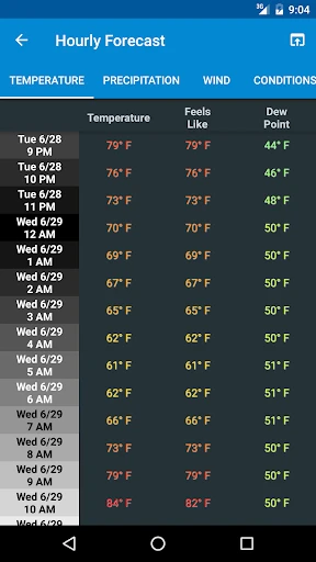
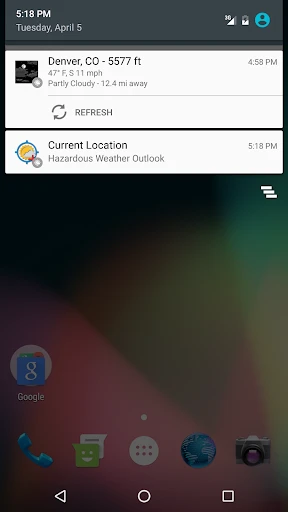
NOAA Weather & Tides: Comprehensive Marine and Weather Data Tool
NOAA Weather & Tides is a specialized mobile application designed to deliver accurate, real-time weather forecasts and tide predictions directly from the National Oceanic and Atmospheric Administration. The app aggregates official NOAA data streams for coastal and inland users, providing hyper-local conditions including wind speed, wave height, atmospheric pressure, and tidal charts. It serves as a critical resource for mariners, anglers, and outdoor enthusiasts who require reliable environmental information for planning and safety. Unlike generic weather apps, this tool focuses on parameter-level detail and scientific accuracy, pulling from NOAA's network of buoys, stations, and satellite observations to ensure data integrity.
Chapter 1: Function
The core function of NOAA Weather & Tides is to present raw and derived NOAA data in an accessible mobile interface. Users can access current conditions and extended forecasts for specific geographic locations, with emphasis on marine metrics such as sea surface temperature, swell direction, and tide tables. The app plots tide height graphs for days ahead, showing high and low tides with precise timing. It also displays wind barbs and gust readings, atmospheric pressure trends, and precipitation probabilities. A radar overlay feature allows near real-time storm tracking. Additional functions include location-based alerts for hazardous conditions like gale warnings or flood stages, and offline access to cached data for remote areas.
Chapter 2: Value
The primary value of NOAA Weather & Tides lies in its authoritative data source and specialized relevance. Users benefit from NOAA's rigorous collection and validation protocols, which are not filtered or simplified by third-party models. This ensures that a recreational boater or a commercial fisherman receives the same data used by professional meteorologists. The app's focus on tides differentiates it from general weather services, as tidal predictions are essential for navigating shallow waters, launching boats, or fishing at optimal times. The value extends to safety: precise wave and wind forecasts help prevent accidents during offshore activities. Additionally, the app reduces reliance on multiple sources by centralizing weather, water, and tide information. For coastal communities and maritime industries, this integration saves time and enhances situational awareness. The app also offers historical data comparisons, enabling users to identify patterns for trip planning. Its reliability in remote areas with limited connectivity adds practical value for field professionals and adventurers. By eliminating unnecessary features and commercial advertisements, the user experience remains focused on functional accuracy, making it a trusted tool for decision-making in weather-sensitive environments.
Chapter 3: Scenarios
The primary target user groups include recreational and commercial boaters, fishermen, surfers, kayakers, and coastal hikers who need precise tide and weather sync for their activities. Everyday use cases involve a sailor checking wind forecasts before a race, a captain reviewing swell predictions for cargo loading, or a fisherman referencing tide tables to determine the best catch window. Coastal event planners use the app to schedule outdoor gatherings around weather windows. Science educators and students leverage the app for field studies on marine environments. Additionally, search and rescue teams utilize the data for operational planning. In non-marine contexts, photographers and wildlife observers rely on tide and sunlight data for optimal coast-side photography. The app is also used by property owners in flood-prone areas to monitor storm surges and rising water levels. Its versatility spans from daily commute decisions for island residents to multi-day expedition logistics for offshore cruisers, making it a staple tool for anyone whose work or leisure is affected by marine and meteorological conditions.
Advantages
- radar loops update every 2-5 minutes for storms
- tide predictions link directly to NOAA buoys data
- offline access to saved location forecasts
- graphical wind speed overlays on map layers
- push alerts for coastal flood advisories
Disadvantages
- no widget for quick glance on home screen
- interface feels cluttered with raw data tables
- requires manual location refresh for tide times
- ads appear after each forecast scroll
- marine zone boundaries not clickable for details
Frequently Asked Questions
Q: What is NOAA Weather & Tides used for?
A: NOAA Weather & Tides provides real-time weather forecasts, marine conditions, and tide predictions sourced directly from NOAA. It covers coastal and offshore areas, displaying wave heights, wind speeds, tidal charts, and storm alerts. The app is designed for boaters, fishermen, and outdoor enthusiasts who need reliable marine data without third-party interpretation.
Q: Is this app free or does it require in-app purchases?
A: The app is free to download and use. It includes optional in-app purchases for ad removal and premium features such as extended tide tables or offline data caching. No subscription is required for core functions like current weather, tide predictions, and NOAA radar imagery. All basic data remains freely accessible.
Q: Does the app work on both iPhone and Android?
A: NOAA Weather & Tides is available for iOS devices on the App Store and for Android devices on Google Play. It requires iOS 13.0 or later for iPhone and Android 8.0 or later for phones and tablets. The app is optimized for mobile screens but is not available for desktop or smartwatch platforms.
Q: How accurate are the tide predictions in the app?
A: Tide predictions are sourced directly from NOAA’s official tide stations and use harmonic analysis with local corrections. Accuracy matches NOAA’s published data, typically within a few minutes and ±0.1 feet under normal conditions. Predictions may deviate during extreme weather or at unmonitored locations. The app displays the nearest station and data freshness timestamp.
Q: Can I use NOAA Weather & Tides offline?
A: Basic cached data from the last session remains viewable offline, including saved tide charts and recent forecasts. However, real-time updates, radar images, and weather alerts require an active internet connection. Premium users can manually download extended tide tables for offline use. GPS position works without connection for location-based tide stations.
Technical Information
Recommended for You

Craftsman Building Sim Games

Autolink

YouTube Music

Photo Collage - Pic Grid Maker

Gmail

X Icon Changer - Change Icons

Droid Dashcam - Video Recorder

Starfall

GameChanger

PixelLab - Text on pictures

TripView

WAMR: Reveal deleted messages!
Weather Radar & Weather Live

Homestyler - Home Design Game

Pawns.app: Surveys for Money

Docx Reader - Office Viewer

Hollister Co.

Cleaner Elite

Vivino: Drink the Right Wine

HaloVPN Pro: Fast VPN Proxy

Verizon Family

Roy VPN - Fast & Secure Proxy

JOWO-Short TV Drama & Movie