NZ Topo50 Offline - North
NZ Topo50 Offline - North
NZ Topo50 offline maps for hikers and explorers
Screenshots

NZ Topo50 Offline - North Overview, Functions, Value, and Scenarios
NZ Topo50 Offline - North is a specialized mapping application designed for outdoor enthusiasts navigating the North Island of New Zealand. It provides high-resolution topographic maps published by Land Information New Zealand (LINZ) at a 1:50,000 scale. The app functions entirely offline after an initial download, allowing users to access detailed terrain data, elevation contours, and geographic features without requiring a cellular or Wi-Fi connection. It is tailored for hikers, trampers, hunters, and emergency services who require reliable navigation in remote areas where digital connectivity is unavailable. The app supports GPS-based location tracking, route planning, and waypoint marking, making it a practical tool for pre-trip preparation and real-time field navigation. Its interface prioritizes clarity and precision over visual frills, ensuring that essential cartographic information remains readable even on small screens or under bright sunlight. By eliminating dependence on internet access, it addresses the common challenge of navigating New Zealand’s rugged wilderness, where phone signals are often absent. The app is available exclusively for the North Island and is part of a broader series covering both islands.
Chapter 1: Function
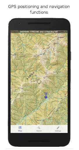
The core functions of NZ Topo50 Offline - North center on providing complete offline access to official topographic data. Users can download the entire North Island map set or select specific grid squares to conserve device storage. Once downloaded, the app displays features such as contour lines at 20-meter intervals, rivers, lakes, tracks, roads, vegetation boundaries, and place names with high accuracy. The GPS functionality shows the user’s current location on the map in real time, even without any network signal. Users can drop custom waypoints to mark campsites, water sources, or points of interest, and record tracks to review their path after a trip. The app also allows for basic distance and bearing measurement between points. Unlike many online mapping tools, it does not include satellite imagery or live traffic data, focusing instead on cartographic reliability for navigation. The search tool enables quick location lookups based on map grid references or place names. All functions operate entirely within the device, with no data transmission required, ensuring privacy and reliability in remote terrain.
Chapter 2: Value
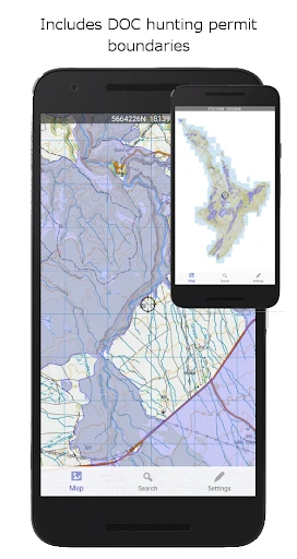
The primary value of NZ Topo50 Offline - North lies in its ability to turn a standard smartphone or tablet into a dependable field navigation tool without recurring subscription fees or data costs. It replaces the need for bulky paper maps while providing interactive features like location tracking and distance measurement. For outdoor users, this app offers significant safety advantages: in New Zealand’s North Island, many popular tramping routes pass through valleys and alpine areas where mobile coverage is nonexistent. By using offline maps with GPS, users can avoid getting lost, identify safe river crossings, and locate emergency access points. The app’s reliance on official LINZ data ensures that the maps are accurate, regularly updated, and compliant with national surveying standards. This makes it a trusted resource for search and rescue teams, conservation workers, and adventure guides who require authoritative geographic information. Additionally, the one-time purchase model provides long-term value compared to subscription-based competitors. The offline capability also extends battery life since the device does not constantly search for signals. For hunters, the detailed vegetation and boundary lines help identify public conservation land versus private property. Overall, the app delivers high reliability, legal data authenticity, and cost efficiency for serious outdoor navigation needs.
Chapter 3: Scenarios
The primary target users of NZ Topo50 Offline - North are trampers, hunters, mountain bikers, and emergency responders operating in the North Island’s backcountry. A typical use case involves a tramper planning a multi-day hike on the Tongariro Northern Circuit: before departing, they download the relevant map tiles on a Wi-Fi connection, then use the app during the trek to verify their location against trail junctions and water sources. Hunters use the app to navigate across trackless terrain in the Kaimanawa Forest Park, relying on contour lines to find deer in steep gullies. Mountain bikers might use it to explore remote trails in the Tararua Range, marking waypoints at stream crossings or lookout points. For search and rescue personnel, the app is critical during incidents in places like the Waitakere Ranges, where they can share grid coordinates with team members despite no phone service. Students and researchers studying geology or ecology in the North Island also use the app to record field observations linked to precise map locations. Everyday use cases include planning weekend tramps from home, checking elevation profiles before a run, or simply identifying distant peaks during a drive through the Northland region.
Advantages
- loads 50k topo tiles without any internet signal
- vector data includes bush
- tracks
- and huts for backcountry navigation
- uses GPS alone for positioning
- no cell tower dependency
- covers entire North Island in one map pack
- grid reference display supports NZTM2000 coordinate system
Disadvantages
- no turn-by-turn routing; manual map reading only
- full download requires over 1GB storage space
- interface lacks search for specific hut or trail names
- no real-time weather overlay or forecasting layer
- map updates require re-downloading the entire package
Frequently Asked Questions
Q: What does this app do exactly?
A: NZ Topo50 Offline - North provides offline access to official LINZ NZTopo50 topographic maps for the North Island of New Zealand. It includes 258 detailed 1:50,000 scale maps with contours, tracks, huts, and place names. No internet connection is needed after download.
Q: Is the app free or does it require in-app purchases?
A: The app is a paid download with a one-time purchase price. There are no recurring subscriptions or additional in-app purchases for the full map set. Users pay once and own all 258 North Island maps indefinitely.
Q: Does it work on my device and which systems are supported?
A: The app runs on iOS and Android devices. It requires iOS 11.0 or later for iPhone/iPad, and Android 5.0 or later for phones and tablets. It is optimized for offline use without GPS dependency, though GPS enhances location features.
Q: How accurate are the maps compared to real terrain?
A: Maps are sourced directly from LINZ (Land Information New Zealand) official NZTopo50 data, accurate to 1:50,000 scale. Contours are at 20-meter intervals. The app displays grid references, elevation data, and official track lines, matching printed paper maps.
Q: Can I use the app without cellular or Wi-Fi signal?
A: Yes, all map tiles are stored locally on your device after initial download. Core functions like viewing maps, zooming, panning, and searching place names work fully offline. GPS location tracking still functions without cellular coverage but requires device GPS hardware.
Technical Information
Recommended for You

The Home Depot

HiWaifu: AI Friend & Waifu Hub

Friend Tracker: Find Anyone

Sweet Hearts Watch Face

MP3 Cutter and Ringtone Maker

JBL Headphones

PlayWell: Play to Earn

TeamSnap: manage youth sports

Learn more about your future

Preference Manager: Addon

PAeDocket

VK: music, video, messenger

Clap to Find My Phone, Whistle

Theme, Widget & Icon changer

Khan Academy Kids

Postmates - Food Delivery

My H-E-B

Weezer-Lite, MP3 Music player

Photo Editor: Retouch, Enhance

Moon Phase Calendar

Hyundai Digital Key

Cinemark Theatres

Remini - AI Photo Enhancer