Avenza Maps: Offline Mapping

Avenza Maps: Offline Mapping
Offline GPS mapping for outdoor explorers with precision
Screenshots
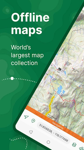

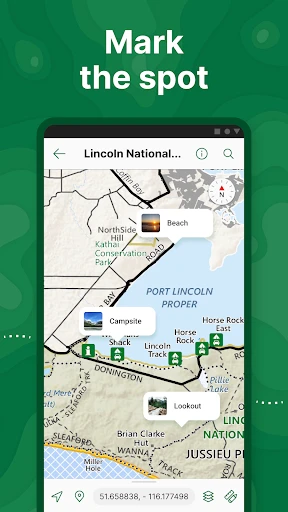
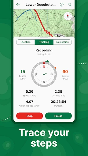
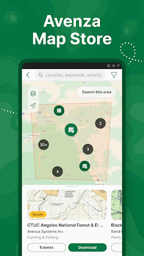
Avenza Maps: Offline Mapping – Your Guide Beyond the Grid
Avenza Maps is a powerful offline mapping application designed for users who need reliable navigation in areas without cellular or Wi-Fi connectivity. Unlike standard map apps that require a constant data connection, Avenza Maps allows users to download high-quality, georeferenced PDF and GeoPDF maps directly to their device and use them with the device's built-in GPS. This makes it an essential tool for outdoor enthusiasts, field professionals, and emergency responders who work or explore in remote, backcountry, or disaster-stricken environments. The app provides accurate location tracking, placemark creation, distance measurement, and compass features, all without incurring roaming charges or relying on mobile networks. It supports a vast library of official and user-submitted maps from sources like the US Forest Service, USGS, National Geographic, and many local hiking and trail associations.
Chapter 1: Function
The core function of Avenza Maps is to enable precise GPS-based navigation using downloaded offline maps. Users begin by browsing the in-app Avenza Map Store to find, download, and import a wide range of official topographic, nautical, and trail maps. Once a map is downloaded, the app uses the device's GPS chip to display the user's exact current position as a blue dot directly on the map, even when flight mode is active. Key functional features include creating and saving custom placemarks, such as campsites, water sources, or trail intersections, and recording GPS tracks of your route to review later. The app supports geospatial coordinate systems, allowing users to view and record their location in UTM, lat/long, MGRS, and other formats. Additional tools include a digital compass, a ruler for measuring distances, and a field sketching tool for marking notes directly on the map. Users can also import their own custom maps via cloud services or direct file transfer, ensuring flexibility for specialized datasets.
Chapter 2: Value
The primary value proposition of Avenza Maps lies in its reliability and accuracy in no-signal zones, offering a level of confidence that standard online maps cannot provide. For outdoor adventurers such as hikers, backpackers, mountain bikers, and hunters, the app eliminates the risk of getting lost in deep wilderness where cellular coverage is nonexistent. It provides a professional-grade tool that replicates the functionality of a dedicated GPS device but uses a smartphone, reducing the need to purchase additional expensive hardware. For field professionals like foresters, geologists, surveyors, and utility inspectors, the ability to view georeferenced PDFs ensures that field data collection is accurate and work can be completed efficiently and safely in remote job sites. During natural disasters, emergency response teams and search-and-rescue crews use the app to coordinate operations on up-to-date maps when local communication networks are down. Furthermore, the app offers a significant cost advantage; while many premium maps are available for purchase, a vast selection of free, high-quality maps from public land agencies is also accessible. The battery-saving offline mode and detailed map layers, including contour lines and terrain shading, provide superior situation awareness in any environment.
Chapter 3: Scenarios
Avenza Maps serves a diverse range of primary target user groups, including outdoor recreationists, professional field workers, and emergency first responders. The most common everyday use case involves a hiker planning a multi-day trip in a national park. Before leaving home, the user downloads the official park topographic map from the Avenza Map Store. During the hike, the user follows their GPS position on the map to stay on the official trail, places a marker at a reliable water source, and records a track of their entire route for post-trip analysis or sharing with friends. Another critical use case is for a field archaeologist working in a remote desert region. They import a custom georeferenced survey map into the app, pin every artifact location with precise UTM coordinates, and measure the distance between dig sites. In a third scenario, a volunteer with a mountain rescue team, during a missing person operation, uses the app to coordinate grids with other searchers, marking which areas have been swept and communicating location data via radio while the phone remains in offline mode. The app is equally valuable for international travelers who wish to avoid roaming fees by downloading city maps for walking tours before leaving their hotel Wi-Fi.
Advantages
- uses gps offline without cellular signal
- import custom geotiff or georeferenced maps
- tracks precise location on scanned paper maps
- export waypoints in kml or gpx format
- large free map store from aerial surveys
Disadvantages
- initial map download requires stable internet
- no turn-by-turn voice navigation
- geotiff calibration can be inaccurate for non-experts
- limited street-level detail vs google maps
- battery drains faster with continuous gps logging
Frequently Asked Questions
Q: What does Avenza Maps do for offline navigation?
A: Avenza Maps allows users to download georeferenced maps for offline use, enabling GPS tracking and navigation without an internet connection. It supports importing custom PDF or GeoPDF maps and uses your device’s built-in GPS to show your real-time location on the map, even in remote areas with no cell service.
Q: Is the app free to use or does it require purchases?
A: The app is free to download and includes basic features like importing up to three maps and using GPS tracking. For unlimited map imports, advanced layer management, and premium map sources, a Pro subscription is required. Some maps from third-party vendors also have their own purchase costs within the app.
Q: Can I use Avenza Maps on both iPhone and Android devices?
A: Yes, Avenza Maps is available for both iOS and Android platforms. It works on smartphones and tablets, requiring iOS 13.0 or later for Apple devices and Android 6.0 or later for Android devices. No additional external GPS hardware is needed for standard location accuracy.
Q: Does the app have any limitations on map file size or format?
A: Avenza Maps supports Geospatial PDF (GeoPDF) and standard PDF map files. Free accounts are limited to importing three maps at a time, while Pro accounts remove this limit. Individual map files should not exceed 2GB, and extremely large or complex maps may affect app performance.
Q: How can I get support if my map fails to load or track accurately?
A: For technical issues like failed map imports or inaccurate GPS tracking, Avenza provides an in-app help center with troubleshooting guides. You can also submit a support ticket through their website. The app does not offer phone support, but response times are typically within 1-2 business days for email inquiries.
Technical Information
Recommended for You

HealthEquity Mobile

Microsoft Power BI

Chirp Audiobooks

EPIK - AI Photo & Video Editor

CineToolkit:Caster&Roku Remote

My6 - Book & Save on Motel6

Barron's: Investing Insights

Little Caesars

Hooked on Phonics Learning

Hindi News by Dainik Bhaskar

Security Camera Mod Minecraft

Cash Giraffe - Play and earn

Ask AI - Chat with AI Chatbot

Earth Camera Online

Zoom Earth - Live Weather Map

MP3 Downloader - Music Player

BURGER KING® App

Tesla Proxy Pro - Safe & Fast

Билеты ПДД 2025 и Экзамен ПДД

MySynchrony

Prank Call - ARMY BLINK Call

Slack

Дом с Алисой